
Massachusetts Bay and Ipswich Bay Marine Forecast
| Tonight...Sw Winds 5 To 10 Kt. Seas 1 Foot Or Less. Wave Detail: S 1 Foot At 3 Seconds And E 1 Foot At 9 Seconds. A Slight Chance Of Showers And Tstms This Evening. Patchy Fog After Midnight With Vsby 1 To 3 Nm. |
| Sun...W Winds 5 To 10 Kt, Becoming Sw In The Afternoon. Seas 1 Foot Or Less. Wave Detail: W 1 Foot At 3 Seconds And E 1 Foot At 9 Seconds. Patchy Fog In The Morning With Vsby 1 To 3 Nm. |
| Sun Night...W Winds 5 To 10 Kt. Seas 1 Foot Or Less. Wave Detail: W 1 Foot At 2 Seconds And E 1 Foot At 9 Seconds. |
| Mon...W Winds Around 5 Kt, Becoming Se In The Afternoon. Seas 1 Foot Or Less, Then Around 2 Ft In The Afternoon. Wave Detail: W 1 Foot At 3 Seconds And E 1 Foot At 9 Seconds, Becoming S 1 Foot At 3 Seconds And E 1 Foot At 8 Seconds. |
| Mon Night And Tue...W Winds 5 To 10 Kt. Seas Around 2 Ft. Wave Detail: S 1 Foot At 3 Seconds And E 1 Foot At 9 Seconds. |
| Tue Night...Nw Winds 5 To 10 Kt. Seas 1 Foot Or Less. Wave Detail: W 1 Foot At 2 Seconds And E 1 Foot At 9 Seconds. |
| Wed And Wed Night...Ne Winds 5 To 10 Kt, Becoming Sw. Seas 1 Foot Or Less. |
| Thu...Sw Winds 5 To 10 Kt. Seas Around 2 Ft. A Chance Of Showers. |
| Thu Night...Sw Winds Around 10 Kt. Seas Around 2 Ft. A Chance Of Showers. Winds And Seas Higher In And Near Tstms. Seas Are Reported As Significant Wave Height, Which Is The Average Of The Highest Third Of The Waves. Individual Wave Heights May Be More Than Twice The Significant Wave Height. |
| Area Forecast Discussion National Weather Service Boston/Norton MA 248pm EDT Sat August 8 2026 .WHAT HAS CHANGED... Forecast remains on track. .KEY MESSAGES... - Diurnal shower and thunderstorm chances remain a threat today. Heat and humidity slowly trending down during Sunday. Dry weather expected Sunday. - Next week trending not as hot and not as humid each day, and possibly slightly cooler than normal by Fri into next week. KEY MESSAGE 1...Diurnal shower and thunderstorm chances remain a threat today. Heat and humidity slowly trending down during Sunday. Dry weather expected Sunday. Typical convective environment across southern New England this afternoon. One of limited bulk shear and modest CAPE values. Isolated thunderstorms already developed across portions of northern MA, with more across eastern NY state. The greatest risk for stronger thunderstorms will be across western MA and CT. Still thinking this risk will diminish after sunset, although thunderstorms could still persist into the later evening. The greatest threat would be straight-line wind damage. Drier weather anticipated for Sunday. Favored the lowest dew point guidance due to expectation of a W wind across the interior. That said, still thinking it will take into the afternoon before dew points reach the lower 60s to upper 50s across the interior. Towards the Cape and islands, dew points should struggle to get much below 70 until some time Sunday night. KEY MESSAGE 2...Very warm and humid weather continues through Wednesday. Daily shower and storm chances each day too, but lesser of a chance Sunday. Overall pretty persistent summer weather pattern really right through Wednesday, with enhanced quasi-zonal flow in mid levels interacting with summerlike temperatures and humidity levels. Warm temperatures and elevated but not really oppressive humidity levels (dewpoints in the mid to upper 60s) can be expected to continue through Wednesday. General sameness to 925-850 mb temps each day, only slightly cooling by a degree or two from Sunday through Wednesday, which supports highs in the mid/upper 80s and heat indices in the lower to middle 90s. While not necessarily a hazardous combo of heat and humidity and most are already acclimatized to the summer warmth, thus not looking at headline- level heat, it is still an extended spell of heat indices in the low to mid 90s, so still continue to adequately hydrate and take breaks in cooler spaces. With westerly mostly non-convergent low-level flow and modest height rises Sunday, Sunday should end up being a generally dry day as will be tough to get enough lift to spark storms. Otherwise, daily shower and thunderstorm chances again resume for early to mid next week, and with somewhat stronger flow, a couple of those storms could become strong or severe in this timeframe. The issue is timing the storms out, as has been the case most of this week; this is very challenging as any ripple in the faster mid-level flow could focus better storm chances given the warm and humid weather. At this forecast time horizon timing specific day(s) have more storm chances than others is a tough ask. Won't be raining and thundering all the time but there will be storms to dodge here-and-there. Tough to find many areas to improve upon NBM so stayed fairly close to outputted NBM forecast values during this period. KEY MESSAGE 2...Next week trending not as hot and not as humid each day, and possibly slightly cooler than normal by Fri into next week. Hudson Bay vortex slowly digs southeast through Ontario and Quebec next week, and in the process, advects numerous short waves into SNE. Each short wave will slowly erode the northwest periphery of the western Atlantic subtropical ridge over SNE. This will result in a risk of scattered showers/thunderstorms each day through Thu. Although, not expecting a washout with many hours of dry weather each day. Hence, a typical mid August week for SNE. In addition, each short wave passage will result in temps and humidity coming down a notch each day. Thus, the week will begin with warmer than normal temps along with dew pts in the 60s. Then finish the week with temps at or slightly cooler than normal by Fri, along with dew pts in the 50s! Marine Forecaster Confidence Levels... Low - less than 30 percent. Moderate - 30 to 60 percent. High - greater than 60 percent. Through Sunday Night... High Confidence. High pressure remains positioned off of the east coast. This will continue to produce a SW flow across the waters this weekend. Gusts to 20 kts possible over the southern waters today, but should remain under SCA (Small Craft Advisory) levels. Outlook /Monday through Thursday/... Monday: Winds less than 25 kt. Monday Night: Winds less than 25 kt. Slight chance of rain showers. Tuesday: Winds less than 25 kt. Tuesday Night: Winds less than 25 kt. Slight chance of rain showers, slight chance of thunderstorms. Wednesday: Winds less than 25 kt. Wednesday Night: Winds less than 25 kt. Slight chance of rain showers. Thursday: Winds less than 25 kt. Chance of rain showers. NOAA Boston MA Office: Watches - Warnings - Advisories CT...None. MA...None. RI...None. Marine None. |
 Boston MA Radar
 Northeast Radar
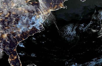 East Coast Satellite