
Cape Cod Bay Marine Forecast
| Rest Of Tonight...Sw Winds 5 To 10 Kt. Seas 1 Foot Or Less. Wave Detail: Sw 1 Foot At 2 Seconds And Se 1 Foot At 9 Seconds. A Slight Chance Of Showers And Tstms. |
| Sat...Sw Winds 5 To 10 Kt, Increasing To 10 To 15 Kt With Gusts Up To 20 Kt In The Afternoon. Seas Around 2 Ft. Wave Detail: Sw 1 Foot At 2 Seconds And Se 1 Foot At 8 Seconds. |
| Sat Night...Sw Winds 10 To 15 Kt With Gusts Up To 20 Kt, Diminishing To 5 To 10 Kt After Midnight. Seas Around 2 Ft In The Evening, Then 1 Foot Or Less. Wave Detail: Sw 1 Foot At 3 Seconds And E 1 Foot At 8 Seconds, Becoming Sw 1 Foot At 2 Seconds And E 1 Foot At 9 Seconds. |
| Sun...Sw Winds 5 To 10 Kt. Seas 1 Foot Or Less, Then Around 2 Ft In The Afternoon. Wave Detail: Sw 1 Foot At 2 Seconds And Se 1 Foot At 8 Seconds. |
| Sun Night...W Winds 5 To 10 Kt. Seas Around 2 Ft In The Evening, Then 1 Foot Or Less. Wave Detail: W 1 Foot At 2 Seconds And E 1 Foot At 8 Seconds, Becoming W 1 Foot At 3 Seconds And E 1 Foot At 9 Seconds. |
| Mon And Mon Night...Sw Winds 5 To 10 Kt. Seas Around 2 Ft. Wave Detail: Nw 1 Foot At 3 Seconds And E 1 Foot At 8 Seconds. |
| Tue...Sw Winds 5 To 10 Kt. Seas Around 2 Ft. |
| Tue Night And Wed...W Winds 5 To 10 Kt. Seas Around 2 Ft, Then 1 Foot Or Less. A Chance Of Showers. |
| Wed Night...Sw Winds Around 5 Kt. Seas 1 Foot Or Less. Winds And Seas Higher In And Near Tstms. Seas Are Reported As Significant Wave Height, Which Is The Average Of The Highest Third Of The Waves. Individual Wave Heights May Be More Than Twice The Significant Wave Height. |
| Area Forecast Discussion National Weather Service Boston/Norton MA 724pm EDT Fri August 7 2026 .WHAT HAS CHANGED... No significant changes. .KEY MESSAGES... - Elevated heat and humidity continues through the weekend. Scattered showers and thunderstorms possible tonight and Saturday afternoon & evening. - Summer warmth and humidity continues along with a daily chance of a pop-up shower or thunderstorm. KEY MESSAGE 1...- Elevated heat and humidity continues through the weekend. Scattered showers and thunderstorms possible tonight and Saturday afternoon & evening. Day Cloud Phase satellite imagery shows development of diurnal cumulus across portions of southern New England this afternoon. SHowers and thunderstorms continue to develop across PA and NY along the periphery of a mid-level ridge shifted offshore of southern New England. For the rest of the afternoon, expect mainly dry conditions. With a few cells beginning to Probability of Precipitation near southern NY, can't rule out an isolated thunderstorm in western MA/CT after 4 PM. Daytime heating has allowed instability values to rise into marginal ranges this afternoon to support pop-up showers/storms. An isolated shower or storm may possibly initiate of the sea breeze boundary along the south coast as well late this afternoon. Hi- res guidance continues to bring a more consistent batch of remnant scattered showers and a few storms after 8pm tonight. The best chance for seeing a storm will be in western southern New England. With precipitable water values approaching 2 inches, brief heavy downpours are possible. This batch of showers/storms are likely to weaken and diminish as they push east overnight. With increased cloud cover for much of the overnight and the warm airmass, overnight temperatures likely remain in the upper 60s and low 70s tonight. Saturday, the mid-level ridge pushes further southeast of the region with flow becoming more zonal. The warm/moist airmass will stay in place tomorrow with SW flow supplying advection of higher dewpoints in the low 70s. Expect another day of elevated humidity and slightly above normal temperatures in the mid to upper 80s. With the added humidity it may feel closer to low to mid 90s. There still is potential for scattered showers and thunderstorms in the late afternoon/evening on Saturday. Model guidance indicated a weak embedded disturbance moving through the flow which should help provide additional support for thunderstorms accompanied by the diurnal heating and moist/unstable airmass. However, there the CAMs continue to show a spread in solutions with regards to potential and location across southern New England. Some solutions indicate more isolated potential, keeping the higher activity south of the region. Others are more robust, simulating a few clusters of thunderstorms pushing across southern New England Sat evening. The primary concern with any storms will be localized heavy downpours supported by PWATs (Precipitable Waters) approaching 1.8". Mid- level flow is sufficient to keep storms moving from west to east which minimizes the concern for more widespread flash flooding issues. Can't rule out localized flash flooding if a storm or two were to push over a more vulnerable area (urban/poor drainage, area of recent heavy rainfall). KEY MESSAGE 2...Summer warmth and humidity continues along with a daily chance of a pop-up shower or thunderstorm. There haven't been many notable changes to the extended portion of the forecast, which encompasses Sunday through the upcoming week. In general, this timeframe features continued summer warmth with manageable humidity and daily chances for afternoon showers or thunderstorms. As mentioned previously, the synoptic pattern trends toward a flattening mid-level ridge, with nearly zonal flow across the CONUS and the subtropical ridge expanding from the western Atlantic into the lower third of the CONUS. This will allow westerly flow with embedded shortwave disturbances to move through the region. Temperatures aloft remain quite warm, with 925mb temperatures around +23C to +25C from Sunday through Tuesday. BUFKIT forecast soundings depict a well-mixed boundary layer, supporting afternoon temperatures well into the upper 80s to around 90F. Dew points will remain elevated, though should fall short of oppressive levels, generally in the 65F to 70F range. Nevertheless, this will contribute to heat indices in the lower 90s Sunday through Tuesday. A potential break from the summer warmth arrives during the middle portion of next week as a front moves through, though there remains a fair amount of spread among the guidance regarding the exact evolution of this feature. Given the uncertainty, stayed close to NBM guidance for Wednesday and beyond, with highs expected to be in the lower to middle 80s. Overnight temperatures will remain seasonably warm, with lows generally in the 60s. Regarding thunderstorm chances, embedded shortwave disturbances moving through the zonal flow should provide sufficient lift for isolated to scattered thunderstorms each day. Storms should remain largely pulse-type and disorganized rather than evolving into organized severe convection. PWATs (Precipitable Waters) up to around 2.0 inches will further support the potential for localized downpours. Gusty winds and frequent lightning will be the primary hazards. That said, thunderstorms will be highly localized, and not every community will see one, with many locations remaining dry. As such, there is no reason to cancel outdoor plans. Marine Forecaster Confidence Levels... Low - less than 30 percent. Moderate - 30 to 60 percent. High - greater than 60 percent. Through Saturday... High Confidence. High pressure remains positioned off of the east coast. This will continue to produce a SW flow across the entire region into the weekend. Gusts to 20 kts possible over the southern waters Saturday, but under SCA. Outlook /Saturday Night through Wednesday/... Sunday through Sunday Night: Winds less than 25 kt. Areas of seas approaching 5 ft. Monday through Monday Night: Winds less than 25 kt. Tuesday: Winds less than 25 kt. Areas of seas approaching 5 ft. Slight chance of rain showers. Tuesday Night: Winds less than 25 kt. Areas of seas approaching 5 ft. Chance of rain showers. Wednesday: Winds less than 25 kt. Seas locally approaching 5 ft. Slight chance of rain showers. NOAA Boston MA Office: Watches - Warnings - Advisories CT... Heat Advisory until 8pm EDT this evening for CTZ002>004. MA... Heat Advisory until 8pm EDT this evening for MAZ003>007- 010>021-026. RI... Heat Advisory until 8pm EDT this evening for RIZ001>007. Marine None. |
 Boston MA Radar
 Northeast Radar
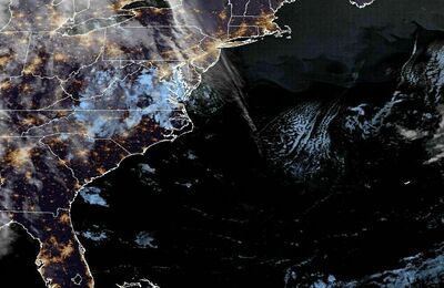 East Coast Satellite