
Baffin Bay to Port Mansfield, TX Marine Forecast
| Today...Southeast Winds 10 To 15 Knots. Seas 3 To 4 Feet. Wave Detail: Southeast 3 Feet At 6 Seconds. |
| Tonight...Southeast Winds 10 To 15 Knots. Seas 2 To 4 Feet. Wave Detail: Southeast 3 Feet At 6 Seconds. |
| Thursday...Southeast Winds 5 To 10 Knots, Increasing To 10 To 15 Knots Late In The Afternoon. Seas 2 To 3 Feet. Wave Detail: Southeast 3 Feet At 6 Seconds. |
| Thursday Night...Southeast Winds 10 To 15 Knots, Diminishing To 5 To 10 Knots Early In The Morning. Seas 2 To 4 Feet. Wave Detail: Southeast 3 Feet At 6 Seconds. |
| Friday...Southeast Winds 5 To 10 Knots. Seas 2 To 3 Feet. Wave Detail: Southeast 3 Feet At 6 Seconds. |
| Friday Night...Southeast Winds 5 To 10 Knots, Becoming Around 5 Knots Early In The Morning. Seas 2 To 3 Feet. Wave Detail: Southeast 3 Feet At 6 Seconds. |
| Saturday...Southeast Winds Around 5 Knots, Becoming East In The Afternoon, Then Increasing To 5 To 10 Knots Late In The Afternoon. Seas 2 To 3 Feet. |
| Saturday Night...East Winds Around 10 Knots, Becoming Southeast After Midnight. Seas 2 To 3 Feet. |
| Sunday...South Winds Around 5 Knots, Becoming Southeast In The Afternoon, Then Increasing To 5 To 10 Knots Late In The Afternoon. Seas 2 To 3 Feet. A Slight Chance Of Showers And Thunderstorms Until Late Afternoon. |
| Sunday Night...Southeast Winds Around 10 Knots, Becoming South Early In The Morning. Seas 2 To 3 Feet. A Slight Chance Of Showers After Midnight. A Slight Chance Of Showers And Thunderstorms Early In The Morning. Winds And Seas Higher In And Near Thunderstorms. |
| Area Forecast Discussion ...UPDATED National Weather Service Brownsville TX 1243am CDT Thu August 6 2026 Issued at 1051pm CDT Wednesday August 5 2026 A 594+ dam high pressure aloft remains persistent over the 4 Corners and southeastern US throughout most of the next 7 days, gradually building and peaking around 597+ dam Friday through Saturday. This is expected to result in another scorching hot day across the region on Thursday (ahead of any potential afternoon clouds/rain) with widespread inland air temperatures soaring into the lower/mid 100s along/west of I-69 E, while inland/coastal areas further east peak into the upper 90s as well as mid 80s along the immediate Gulf coast. As has been the recurring pattern for this ongoing weather setup, a SPS is likely to be issued overnight tonight or Thursday morning for all inland and coastal portions of deep south Texas as Thursday afternoon heat indices are expected to climb to at least 108-111 F. A heat advisory remains possible, particularly for inland portions of Kenedy and Willacy counties, for apparent temperatures of 111-113 F. Meanwhile, a series of shortwaves traversing the northern and eastern periphery of the high's ridge leads to a southwestward extension of mid/upper level troughing to the Southern Plains from the Midwest, lowering heigheights just a bit as well as building cloud coverage and moisture content, resulting in a daily chance of rain along the afternoon/early evening seabreeze boundary Thursday into Sunday. Guidance still remains a bit incohesive at this time, but there is a 15-20% chance of isolated showers and a few thunderstorms across the Northern Ranchlands on Thursday and the Lower/Middle Rio Grande Valley on Friday, where chances increase to a 20-30% on Saturday, followed by a low to medium (20-40%) chance along/east of US-281 on Sunday, highest along/east of I-69 E. Yet, again, models continue to diverge a fair amount on overall coverage and deepness of convection, with brief periods of heavy rain, frequent lightning and some gusty winds not out of the question, especially over the weekend as pockets of PWAT (Precipitable Water) values could exceed 2.0 in. Regardless, this is likely to gradually lower temperatures by a few degrees Friday into Sunday, with lower 100s mainly limited to the Rio Grande Plains and the Upper Rio Grande Valley as well as kick heat indices down to around 105-110 F across the region, with mostly moderate heat risks and pockets of minor. Following, high pressure aloft begins to stretch across the Southern Plains to another building high pressure over the northeastern Gulf, re-enhancing subsidence aloft, diminishing cloud cover/rain chances and causing temperatures to rebound; widespread lower/mid 100s high temperatures and moderate to major heat risks return by Monday, gradually deteriorating to major, with pockets of extreme, by the middle of next week. Additional SPSs and/or heat advisories are likely as heat indices maximize around 108-111 F for most locations. A moderate risk of life-threatening rip currents continues through Thursday afternoon. Marine Issued at 1051pm CDT Wednesday August 5 2026 Moderate to fresh southeasterly winds become mostly gentle to moderate on Friday and through the weekend before re-enhancing back to moderate to fresh by the beginning of next week. Chances of showers and thunderstorms increase from a low (15-20%) chance to as much as a low to medium (30-60%) chance Saturday and Sunday before gradually winding down to 10% or less by next Monday or Tuesday. Slight to moderate (2-4 ft) seas continue, with periods of Small Craft Exercise Caution conditions possible from time-to- time. NOAA Brownsville TX Office: Watches - Warnings - Advisories TX...None. GM...None. |
 Brownsville TX Radar
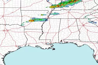 Gulf Radar